On This Day: August 24, 1992 — Hurricane Andrew Erased a Town Overnight
At 3 AM on August 24, 1992, the radar screen at the National Hurricane Center in Coral Gables, Florida showed a tightly wound storm bearing down on the coast. By 3:40 AM, the radar was gone — stripped off the roof by winds exceeding 175 mph. South Florida was on its own, in the dark, in the middle of the worst hurricane to make U.S. landfall in 27 years. The cavalry, as Dade County’s emergency director would famously demand three days later, was nowhere yet.
From a Disorganized Wave to a Category 5 Monster
Andrew’s origin gave no hint of what it was about to become. It formed off the West African coast as a tropical wave on August 14, 1992, and spent the following week barely holding together over the open Atlantic. Meteorologists tracked it without urgency — the system was disorganized, slow-moving, prone to falling apart entirely. It almost did, twice.
Then, on August 21, the storm passed over a stretch of unusually warm Atlantic water and underwent what meteorologists call rapid intensification. In less than 36 hours, Andrew went from a minimal tropical storm to a Category 4 hurricane. By the time it crossed the Bahamas on August 23 — making its first landfall on Eleuthera Island with 150 mph winds — the forecasts had turned urgent. The Bahamas took $250 million in damage from that first crossing. That destruction was a preview, and most of South Florida was too busy evacuating to pay close attention to what it implied.
The Retro Almanac
A monthly roundup of "on this day" highlights from that month, decades back — plus first dibs on new retro merch drops. No spam, just the good stuff.
One million people received evacuation orders across South Miami-Dade County on the night of August 23. Most of them left. A million more, for reasons ranging from skepticism about Andrew’s exact track to nowhere safe to go, stayed home and waited for the wall of wind to arrive.
5:05 AM: Homestead Takes the Full Force
Hurricane Andrew made its Florida landfall near Homestead at 5:05 AM local time on August 24, 1992. The storm’s central pressure had dropped to 922 millibars — among the lowest ever recorded at a U.S. hurricane landfall — meaning the air pressure differential driving the winds was extreme. Sustained winds at landfall were 165 mph. Peak gusts reached 175 mph, a reading captured by the National Hurricane Center’s own instruments in the minutes before they were destroyed.
Homestead was a working-class town of roughly 26,000 people, 25 miles south of Miami, in the direct path. The storm crossed the entire Florida peninsula in less than five hours. That speed limited the flooding that typically accompanies slow-moving systems, but it concentrated the wind violence into a narrow, intense corridor. Andrew didn’t linger. It arrived, worked methodically through the housing stock, and left for the Gulf.
The scattered reports that reached emergency managers during the pre-dawn hours were so uniformly catastrophic that officials initially read them as exaggerated. They weren’t.
What 165 mph Winds Do to a City
Mobile homes — the housing of choice for tens of thousands of working-class families in South Miami-Dade County — fared the worst. Surveys conducted after the storm found that 99% of mobile homes in the hardest-hit areas were completely destroyed. Not damaged. Not partially standing. Gone. Reduced to scattered debris that had to be identified rather than simply removed.
Conventional houses did better, though the word “better” requires context. 63,500 homes were destroyed outright across the affected area. Another 108,000 sustained major damage. By the time the sun came up on August 24, 175,000 people had no home to return to.
Homestead Air Force Base, a military installation that had served through the entire Cold War, was effectively erased. Every structure on the base took significant damage. Hangars collapsed. Control towers were left leaning. The base was subsequently decommissioned — the military installation that existed before August 24, 1992 never reopened in its original form. An Air Reserve Base occupies part of the footprint today, but Homestead AFB is gone.
Engineers who later examined the wreckage made a finding that would fundamentally reshape Florida construction law: homes built before stricter codes, particularly those from the 1950s and 1960s, had essentially disintegrated. A small percentage of newer structures built to higher wind-resistance standards held. The difference in outcomes wasn’t random luck. It was entirely predictable given how the buildings had been put together.
The Human Toll and the FEMA Controversy
Twenty-three people died directly from Andrew in the United States. Three more died in the Bahamas during the storm’s first landfall on Eleuthera Island. Indirect deaths — accidents during evacuation, medical emergencies in the days following landfall, injuries sustained during cleanup — brought the total closer to 65. The numbers are precise, and they’re still not adequate to convey what happened in Homestead before sunrise on August 24.
The federal response moved slowly. In the days following landfall, 175,000 displaced people were sleeping in ruined structures, in vehicles, in parking lots. Clean water was scarce. Power was out across a swath of South Florida larger than some states. The communication infrastructure had been badly damaged. Relief organizations were overwhelmed. FEMA, the Federal Emergency Management Agency, struggled to coordinate a response at the scale the disaster required.
The breaking point came three days after landfall. On August 27, Kate Hale, the Director of Emergency Management for Dade County, stood before cameras and asked a question that played on national television within hours: “Where in the hell is the cavalry on this one?” It was genuine frustration from someone watching her county collapse without adequate support from Washington. The broadcast forced the hand of the George H.W. Bush administration, which rapidly accelerated the deployment of 20,000 federal troops and National Guard personnel — the largest domestic military mobilization in American history to that point. Andrew’s destruction of FEMA’s credibility contributed to agency reforms over the following years, though the lessons from 1992 proved insufficient to prevent the even more catastrophic failures of the Katrina response in 2005.
The $27 Billion Price Tag That Broke the Insurance Industry
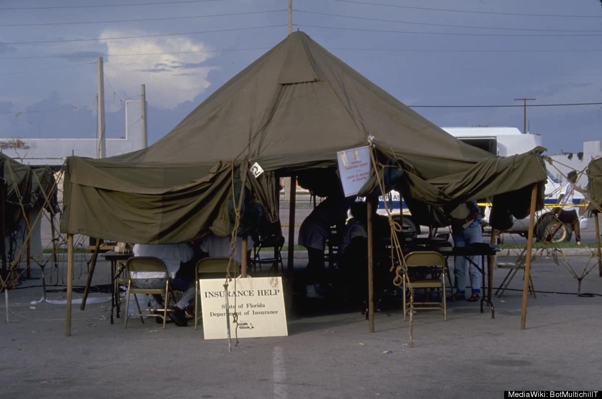
Andrew caused approximately $27 billion in total damage in 1992 dollars, a figure equivalent to roughly $59 billion today. At the time, it was the most expensive natural disaster in American history. That record stood until Hurricane Katrina struck the Gulf Coast in August 2005.
Eight insurance companies went bankrupt as a direct result of Andrew’s claims. The total insured loss was approximately $15.5 billion — a figure so far beyond the industry’s internal catastrophe models that it forced a global reassessment of how reinsurance risk was priced. Premiums climbed worldwide. Florida’s property insurance market entered a crisis from which it has genuinely never recovered. The insurance problems that plague Florida homeowners today — the exits of major insurers, the high premiums, the chronic unavailability of comprehensive coverage in certain zip codes — trace a direct and documented line back to the morning of August 24, 1992.
How Andrew Changed the Rules
Florida’s building codes were comprehensively overhauled in the years following Andrew. The new standards mandated wind-resistant windows and doors, stronger roof-to-wall connections, more rigorous structural anchoring, and stricter inspection regimes during construction. The Miami-Dade code — covering the counties that took the direct hit — became one of the strictest building standards in the world. It remains in effect today, and the homes built under it perform measurably better in major storms than anything constructed before Andrew showed what was necessary.
The meteorological record on Andrew also has an unusual footnote. When the storm made its Florida landfall in August 1992, it was officially classified as a Category 4 hurricane. A decade later, in 2002, researchers using improved analytical methods re-examined the surface wind data and retroactively upgraded Andrew to Category 5. The reclassification changed nothing about what happened on the ground — it just confirmed in the official record what anyone who had seen Homestead after sunrise on August 24 already understood intuitively.
The science of hurricane forecasting also advanced significantly in Andrew’s aftermath. The rapid intensification that transformed the storm from a minimal disturbance into a Category 5 over warm Atlantic waters was something the computational models of 1992 couldn’t predict reliably. The research investment triggered by Andrew contributed directly to the satellite and atmospheric modeling improvements that now routinely give coastal communities three to five days of useful warning before major landfall. In 1992, 12 to 24 hours was considered adequate lead time. The gap between those two standards is, in large part, Andrew’s scientific legacy.
For the kind of week-in-history moments that define decades, August 24, 1992 lands differently than most. It’s not connected to ideology or political maneuvering, unlike the Soviet coup attempt that had shaken the world the previous year. It has none of the compressed tragedy of something like a plane crash or the slow-building horror of a geological catastrophe. Andrew was just physics — warm water, low pressure, high wind — operating without regard for the 175,000 people in its path.
Homestead, Florida rebuilt. Today the town looks like any South Florida suburb, and a visitor who didn’t know the history would see nothing unusual. The legacy of August 24, 1992 lives in the building codes that govern every new structure in South Florida, in the insurance market that still hasn’t fully stabilized, in the emergency management protocols that shape how the region prepares for each hurricane season, and in the satellite technology that now tracks storms with a precision that 1992 forecasters could only dream about. The storm came through in the pre-dawn hours of a Tuesday morning and changed all of those systems permanently. That’s what a Category 5 does when it lands on a city that wasn’t ready.
Love the retro era? Browse our shop for vintage finds, retro clothing, and 80s/90s nostalgia gear.
Sources
- NOAA/NESDIS — Hurricane Andrew at 30: A Look Back from Above — Satellite imagery analysis and storm history from the National Environmental Satellite, Data, and Information Service.
- National Weather Service — Hurricane Andrew’s 30th Anniversary — Meteorological record, damage statistics, and timeline of events from the NWS.
- NOAA/AOML — 25th Anniversary of Hurricane Andrew — Ground-level damage documentation and research legacy from NOAA’s Atlantic Oceanographic and Meteorological Laboratory.
Image credit: historycollection.com
The Retro Almanac
A monthly roundup of "on this day" highlights from that month, decades back — plus first dibs on new retro merch drops. No spam, just the good stuff.